As a teacher who practices project-based learning, I try to design projects that not only engage my students, but also make an impact in some way. For the Earthquake Microgrant Project, my students identified a part of the world and produced a two minute pitch video that explained why their area was in need of mapping. They had to show that houses currently weren’t mapped and it was an area that was geologically prone to earthquakes because it had a history of earthquakes and was near a plate boundary. I modeled the project after the work of Humanitarian OpenStreetMap Team (HOT). HOT works with communities and local disaster management agencies to map and understand disaster risk by developing detailed maps of roads and buildings. Data is then used to produce realistic scenarios of natural disasters. This allows community leaders to better plan, prepare and respond to these natural disasters.
In my 9th and 10th grade Earth Science classes, students must understand that plate boundaries are the sites of most earthquakes and that earthquakes present geologic hazards to humans. Effective emergency preparedness is key to preventing loss of life, property and personal injury. Students learned through OpenStreetMap and HOT’s work that there are places that are missing from the map. If these places are in earthquake prone areas, it will be difficult for rescue workers to respond. Hence, students were to research an area that was prone to earthquakes, understand the geologic forces at work, and find places that were missing from the map. While this was an engaging project the year prior, it was missing one thing: students wanted to actually map the area.
I had no experience with OpenStreetMap, yet I knew it was the key to making the project a success. I dove into the resources at TeachOSM and joined their biweekly mapping session, where we mapped green spaces in urban areas. I also reached out to Dr. Mike Jabot, who facilitates the YouthMappers chapter at SUNY Fredonia, and he showed me how to use ArcGIS to see the satellite images that we would use to locate the houses and roads that were missing from OpenStreetMap.
Though at this point I had little experience with the technology, I decided to jump headfirst into figuring it out with the students. I explained that we would be learning together, and if we had an issue, we would figure it out with the help of our experts at TeachOSM, our IT Department, and the resources provided by the TeachOSM website. We initially had an issue with student emails rejecting the confirmation, but our IT Director quickly aided us in setting up our accounts. Because we were all in the same general area, I could keep track of students’ edits and ensure they were not duplicating information.
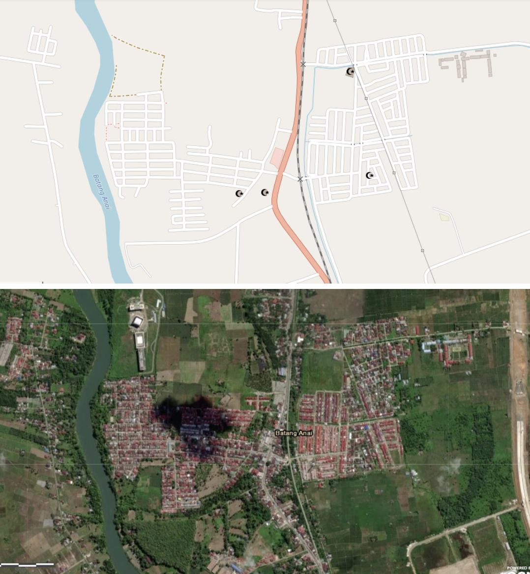
Students mapped Batang Anai, Pariaman, West Sumatra, Indonesia shown here on satellite imagery and in OpenStreetMap
I structured the mapping to take place on a day just before spring break, so it was exciting to see students still mapping during their lunch break. On a day when it is increasingly difficult to keep student attention, mapping using OSM provided a way for students to give back to the community, have fun and learn at the same time. Hailey, a freshman, stated “the mapping was therapeutic and better than normal projects because we were directly helping people.” Abigail, who continued mapping through her study hall and lunch, felt the mapping project was important because it helped show where people were in case they truly needed help. Danielle, also a freshman, liked mapping because “it was a new way to learn and help others in disasters like an earthquake.”
Though mapping only seemed like something that applied to geography classes, I learned quickly how much authenticity and meaning mapping in OpenStreetMap afforded my earth science classes. As a bonus, when you create a culture in your classroom that allows learning together, you don’t have to fear not being the expert. I highly recommend using the resources at TeachOSM and joining a mapalong to help you feel confident that mapping can connect in any classroom. You may be surprised how much fun your students will have.
Written by Jamie Dickinson, Earth Science Teacher at Northville High School
Do you have a story to share about how you are using OpenStreetMap in the classroom? Reach out at info@teachosm.org!